|
|
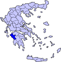
'Agios Ilias, Agios Ilias or Ayios Ilias (Greek: Άγιος Ηλίας meaning Saint Elias) is a village located in the municipality of Amaliada in the northern part of the prefecture of Ilia in the western part of the Peloponnese. It is passed by a road linking Kentro and Keramidia which is mainly gravel and paved in the village area. It is located 19 km ESE of Gastouni, about 9 km S of Borsi and 3 km S of Kentro, about 13 km W of Simopoulo, 13 km NE of Amaliada, about 25 km N of ENE of Pyrgos and 18 km E of GR-9/E55 from the southbound lanes and about 20 km NE from the northbound lanes. It is south of the Pineios River. The reservoir is situated to the east over a valley which was flooded in the 1960s. Nearest places
Geography Location:
Postal code: 270 69 Elevation:
Dialing code: +11+30-26220 (030-26220)
Historical population Year Communal population Change 1981 145 - 1991 409 264/182% Agios Ilias' growth from 1981 to 1991 was one of the fastest in the prefecture. Agios Ilias has a small school a church named Agios Ilias and a square (plateia). Residential areas are around the centre and is shaped with a triangularly. The view of mounts Scollis and Erymanthos and the hills of the Peneus valley can most easily be seen from the northern part of Agio Ilias. The area sits on a hill slopes with farmlands, groves and forests lying in the central part while grasslands with a few forests dominate the rest of the land especially in the west.
See also
 |
|
|||||||||||||||||