|
|
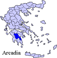
Anavryto (Greek: Αναβρυτό), pre-1990s, Anavrito is a community divided into two villages, Ano Anavryto which is on the western part of mount Tsiberou, and Kato Anavryto on the other side of the valley, west of Anavryto. The nearby communities are Amenodouri to the north. Distance from Megalopoli is 16 km, and 38 km from Tripoli.
Geography Location: Latitude:
Longitude:
Postal code: 220 21 Elevation: 670 m (Anavryto), 630 m (Kato Anavryto) Dialing code: +11+30-27910 (030-27910)
Historical population
Anavryto has a school, a church named Agia Marina, a mailbox, and transmitters for Megalopoli on top of Tsiberou. The eastern part has one street name. Ano Anavryto is bypassed to the east. Kato Anavryto is mainly residential. Much of the area are deforested and rocky. The center of Ano Anavryto is in the eastern part while residential homes are to the west. Much of the population left and much of the houses are abandoned. Until 1927, the village was known as Gardiki (Γαρδίκι). Until the 1960s, the village was isolated, it did not have electricity and didn't had paved roads or the little perimeter road. Until the mid-1980s, much of the houses were stone-built.
Links University of Patras on Anavryto (in Greek)
See also:
 |
|
||||||||||||||||||||||||||||||||
|
|