Platanias

Periphery: Crete
Prefecture : Chania

Platanias Municipality

Chania Municipalities, Satellite Image

Platanias (Greek: Πλατανιάς) is a village of the Platanias municipality, Chania prefecture, on the Greek island of Crete. It is located about 10 km from the city of Chania via GR-90 (E65, Kastelli-Kissamos - Chania) and east of Kastelli-Kissamos and is by Chania Bay. It is a popular tourism village with a beach, several hotels, restaurants and souvenir shops. Not far from the coast is the island of St. Theodori (or Agioi Theodoroi).

Statistics
Prefecture: Chania
Province: Kydonia
Seat: Gerani
Location:
Latitude:
Longitude:

35.5155/35°30'51" N .
23.9042/23°54'16" E
Population: (2001) 5.225
Elevation:
 -lowest:
 -centre:
 -highest:

Chania Bay
about 10 m (centre)
southern part
Postal code: 730 04
Area/distance code: 11-(00)30-28210-6
Municipal code: 5321
Car designation: XB and XN
3-letter abbreviation: CPL (Chania - Platania)
Website: www.platanias-village.gr

Historical population

Year Population Municipal Population
1981 630 -
1991 719 5044
2001 666 5225

Links

Coordinates: 35°30′51″N, 24°54′16″W

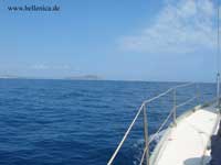
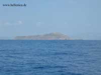
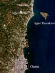
Agioi Theodoroi (Theodorou) island, near Agia Marina and Platanias. Klick image to enlarge

Division of the Platanias Municipality, population 5225 (in the year 2001)

  • Gerani / Δ.δ. Γερανίου [ 1.222 ]
    • Gerani / το Γεράνι [ 666 ]
    • Loutrakion / το Λουτράκιον [ 110 ]
    • Palaion Geranion / το Παλαιόν Γεράνιον [ 446 ]
  • Vlacheronitissa / Δ.δ. Βλαχερωνιτίσσης -- η Βλαχερωνίτισσα [ 145 ]
  • Vryses Kydonias / Δ.δ. Βρυσών Κυδωνίας [ 413 ]
    • Vryses / οι Βρύσες [ 245 ]
    • Pantellarion / το Πατελλάριον [ 168 ]
  • Zounakion / Δ.δ. Ζουνακίου [ 183 ]
    • Zounakion / το Ζουνάκιον [ 59 ]
    • Limni / η Λίμνη [ 124 ]
  • Kontomarion / Δ.δ. Κοντομαρίου [ 460 ]
    • Kontomarion / το Κοντομάριον [ 235 ]
    • Koilada / η Κοιλάδα [ 40 ]
    • Metochion / το Μετόχιον [ 128 ]
    • Xirokampion / το Ξηροκάμπιον [ 57 ]
  • Kyparissos / Δ.δ. Κυπαρίσσου [ 168 ]
    • Kyparissos / ο Κυπάρισσος [ 118 ]
    • Maroulachiana / τα Μαρουλιαχιανά [ 50 ]
  • Maleme / Δ.δ. Μάλεμε -- το Μάλεμε [ 708 ]
  • Manoliopoulon / Δ.δ. Μανολιοπούλου [ 327 ]
    • Manoliopoulon / το Μανολιόπουλον [ 258 ]
    • Apothikes / οι Αποθήκες [ 69 ]
  • Modio / Δ.δ. Μοδίου -- το Μόδιο [ 268 ]
  • Deres / Δ.δ. Ντερέ [ 196 ]
    • Deres / ο Ντερές [ 172 ]
    • Pappadiana / τα Παππαδιανά [ 24 ]
  • Xamoudochorion / Δ.δ. Ξαμουδοχωρίου -- το Ξαμουδοχώριον [ 161 ]
  • Platanias / Δ.δ. Πλατανιά -- ο Πλατανιάς [ 744 ]
  • Sirilon / Δ.δ. Σιριλίου [ 230 ]
    • Sirilon / το Σιρίλιον [ 136 ]
    • Ellinikon / το Ελληνικόν [ 55 ]
    • Metochion Siriliou / το Μετόχιον Σιριλίου [ 39 ]


North: Sea of Crete (Chania Gulf)
West: Voukolies Platanias East: Nea Kydonia
South: Mousouri

Divisions of the Chania prefecture

Provinces of the Chania prefecture

Apokoronas | Kissamos | Kydonia | Selino | Sfakia

Municipalities of the Chania prefecture

Akrotiri | Anatoliko Selino | Armeni | Chania | Eleftherios Venizelos | Fres | Georgioupoli | Innachori | Kandanos | Keramia | Kissamos | Kolymvari | Kryonerida | Mousouri | Mythimna | Nea Kydonia | Pelekanos | Platanias | Sfakia | Souda | Theriso | Vamos | Voukolies

Non-municipal communities of the Chania prefecture

Asi Gonia | Gavdos

Retrieved from "http://en.wikipedia.org/"
All text is available under the terms of the GNU Free Documentation License

A - B - C - D - E - F - G - H - I - J - K - L - M

N - O - P - Q - R - S - T - U - V - W - X - Y - Z

Γεωγραφία της Ελλάδας

Ancient Greece

Medieval Greece / Byzantine Empire

Modern Greece

Science, Technology , Medicine , Warfare
, Biographies , Life , Cities/Places/Maps , Arts , Literature , Philosophy ,Olympics, Mythology , History , Images

Science, Technology, Arts
, Warfare , Literature, Biographies
Icons, History

Cities, Islands, Regions, Fauna/Flora ,
Biographies , History , Warfare
Science/Technology, Literature, Music , Arts , Film/Actors , Sport , Fashion

Cyprus

Greek-Library - Scientific Web