Agioi Theodoroi

Statistics
Prefecture: Corinthia
Location:
Latitude:
Longitude:

37.91667/37°55' N lat.
23.083/22°5' E long.
Area:
-Total
-Water
-Rank

km²

Rank xxth
Population: (2001) 5960
Elevation:
 -lowest:
 -centre:

sea level
m(centre)
around 1,100 m at Geraneia
Postal code: 200 03
Area/distance code: 11-30-27410 (030-27410)
Municipal code: 3001
Car designation: KP
3-letter abbreviation: AGT (Agioi Theodoroi)
Address of administration:
Agioi Theodoroi 200 03

Agioi Theodoroi (Άγιοι Θεοδώροι) sometimes Aghioi Theodoroi, Ayioi Theodoroi or Agii Theodorii or Ayii Theodorii is a municiipality of Corinth prefecture located around 12 km east of the city Corinth and about 63 km W of Athens. Its population is 5960 (2001). It has one toll interchange with GR-8A first opened in 1995, and a braking lot. The south contains beach, the west is bounded by the Corinth Refinery with Kalamaki. hills and mountains dominate the northern part, and the Attica boundary with Kineta (Kinetta) to its east. The municipality is bounded with Loutraki in the west and Megara in the east. Agricultural used to dominate before the 1960s and the 1970s. Now most of the agricultural land is in the north and the east. Some houses are summer homes.

Settlements

  • Agia Paraskevi
  • Katsivari?
  • Stena

Nearest places

  • Kineta (east)
  • Kalamaki (west)

Historical population

Year Municipal population
1981 2660
1991 5084
2001 5960

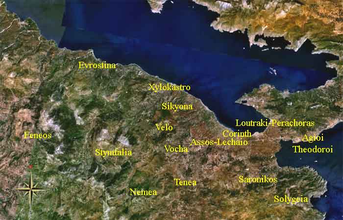
History

In 2001, a fire started on a mountain north of Aghioi Theodori and south of Geraneia mountains. It lasted days. It spread close to the refinery, and the town and smoke covered the main freeway and highway, road closres took place. A couple of houses especially in Kineta were burnt down. A soon as firefighters put out the fire, the fires were stopped.

On July 31, 2005, two days after the enormous Attica Fire near Rafina, another enormous fire reaching as high as 15 to 30 m ravaged the settlements of Agia Paraskevi and Katsivari northeast of the downtown area of Agioi Theodoroi near the Geraneia mountains where it contains virgin pine trees that covers the southern and the western parts of the mountains which were almost threatened and down to the superhighway/service road (second highway), the forests near the mountain started in the afternoon hours and partly in Kineta in the Attica prefecture. The flames were threatening and roamed faster like the East Attica Fire of July 29. One of the fires ravaged several houses in the settlement of Agia Paraskevi lying near the forests to the northeast, the firefighters began to use the stairs in one of the affected houses to put out the fire before it caused damages. Hundreds to thousands of hectares were contained. Smoke covered the northeastern part.

Links

See also

Communities of Corinthia

Retrieved from "http://en.wikipedia.org/"
All text is available under the terms of the GNU Free Documentation License

A - B - C - D - E - F - G - H - I - J - K - L - M

N - O - P - Q - R - S - T - U - V - W - X - Y - Z

Γεωγραφία της Ελλάδας

Ancient Greece

Medieval Greece / Byzantine Empire

Modern Greece

Science, Technology , Medicine , Warfare
, Biographies , Life , Cities/Places/Maps , Arts , Literature , Philosophy ,Olympics, Mythology , History , Images

Science, Technology, Arts
, Warfare , Literature, Biographies
Icons, History

Cities, Islands, Regions, Fauna/Flora ,
Biographies , History , Warfare
Science/Technology, Literature, Music , Arts , Film/Actors , Sport , Fashion

Cyprus

Greek-Library - Scientific Web