Lavara

Periphery: East Macedonia and Thrace
Prefecture : Evros

Lavara, (Greek: Λάβαρα) is a town licated in the eastern part of the prefecture of Evros. It is the seat of the municipality of Orfeas (Greek: Ορφέας). It is located only nearly 2 km from Turkey and the western banks of the Evros. The nearest Turkish settlement is Alibey. Orfeas is one of the largest municipality and the leastly populated municipality in the prefecture. Much of the land are mountainous and forested to the west hovering the central and the western part of the prefecture extending up to the Rhodope prefecture. It is linked with GR-51 (Alexandroupoli - Orestiada - Edirne in Turkey and Svilengrad in Bulgaria). The town sits on a plain. It is located SE of Svilengrad, S of Edirne, Turkey and Orestiada, and 13 km N of Soufli and 78 km N of Alexandroupoli.


Lavara, School and Church,

Orfea - Statistics
Prefecture: Evros
Province: Didymoteicho
Location:
Latitude:
Longitude:

41.268/41°16'6'' N .
26.7845/26°23'3'' E
Population: (2001)
 - Total
 - Density ¹
 - Rank

 6,905

 -10.73/km ²
Elevation:
 -lowest:
 -centre:
 -highest:

about 18 m in the Soutf part (Evros river)
20 m(centre)
Rhodope mountains
Number of communities: 6
Postal code: 680 04
Area/distance code: 11-30-25530 (030-25530)-3
Municipal code: 1307
Car designation: OP
3-letter abbreviation: ORF Orfeas
Name of inhabitants: sing.
-s pl.
Address of administration: 75 Konstantinoupoleos St.
Lavara 680 04

Communities

  • Amorio
  • Kyriaki
  • Mandra
  • Mavroklisiou
  • Mikro Denio
  • Protoklisiou

Nearest places

  • Didymoteicho, NE
  • Kissari, east
  • Mandra, west

Historical population

Year Population Municipal population
1981 2117 -
1991 2173 4392
2001 1580 6146

Geography

Forests dominates the banks and parts of the plain. Much of the area are used for farming. The main production are cattle, fruits and vegetables and some flowers. The mountains dominate further west.

History

The town were rare affected by the Evros river flooding of February 17 to 22, 2005. Flood warnings were reported that time. It devastated much of the town on Wednesday March 2, 2005 and continued for several days. On Friday March 4, flood waters plummeted slowly. It amounted up to 5 m or 5,000 mm of rainfall causing the rover to overflow its banks. It flooded buildings, properties and stores. It also left people stranded in their homes and buildings. 50 houses were damaged. It was the worst flooding in nearly 50 years. The rail south of Lavara and near the station were also flooded and was closed that time.

Other

Lavara has a school, a lyceum, a gymnasium, churches, banks, a police station, a water tower, a post office, a library, and a square (plateia).

References

  • http://thesaurus.duth.gr/english/moredata.asp?Perioxh_ID=42&Subj=255
  • Evros floods
  • Critical hours in Lavara during the floods - pathfinder.gr
  • http://www.imerisia.gr/pages/01002000001. asp?
  • http://orfeas.evros.gr/lavara.htm (in Greek)
Northwest: Bulgaria North: Metaxades Northeast: Didymoteicho
West: Kechros (community)
Orfeas East: Turkey
Southwest: Alexandroupoli and Ariana South: Soufli

Municipalities of the Evros Prefecture

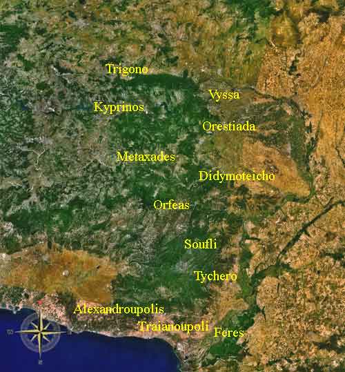
Alexandroupoli | Didymoteicho | Feres | Kyprinos | Metaxades | Orestiada | Orfeas | Samothrace | Soufli | Traianoupoli | Trigono | Tychero | Vyssa

Retrieved from "http://en.wikipedia.org"
All text is available under the terms of the GNU Free Documentation License

A - B - C - D - E - F - G - H - I - J - K - L - M

N - O - P - Q - R - S - T - U - V - W - X - Y - Z

Ancient Greece

Medieval Greece / Byzantine Empire

Modern Greece

Science, Technology , Medicine , Warfare
, Biographies , Life , Cities/Places/Maps , Arts , Literature , Philosophy ,Olympics, Mythology , History , Images

Science, Technology, Arts
, Warfare , Literature, Biographies
Icons, History

Cities, Islands, Regions, Fauna/Flora ,
Biographies , History , Warfare
Science/Technology, Literature, Music , Arts , Film/Actors , Sport , Fashion

Cyprus

Greek-Library - Scientific Web