|
|
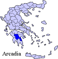
Tripotamia (Greek: Τριποταμιά meaning three rivers fr. τρι tri- + ποτμια potamia, a plural form of river), pronunciation: Tripotamiá, tree-poh-tah-mee-AH/MYAH, is a village located in the municipality of Tropaia in the westernmost part of the prefecture of Arcadia in the west-central Peloponnese. It is passed with GR-74 with a narrow one-lane bridge over the Erymanthus river. It is located about 50 (old: 60) km E of Pyrgos, about 40 km E of Olympia, S of Lampeia, SSW of Kalavryta, W of Tripoli and Dimitsana, NW of Karytaina and Megalopoli and N of Andritsaina. The rivers of Ladon to the east, Alpheus to the south and the Erymanthus to the west are in that area in which the origin of the town's name comes from. At the Erymanthus river to the west and the Alpheus river is the boundary with the prefecture of Ilia.
Nearest places Tropaia
Geography Location:
Postal code: 220 08 Elevation:
Dialing code: +11+30-27970 (030-27970)
Historical population
Tripotamia has a small school a church and a square (plateia). Residential houses and within the valley. Much of the area are hilly and mountainous and are covered with forests with a few bushes. The farmlands with pastures and some groves are in the valley areas. Links http://arcadia.ceid.upatras.gr/arkadia/places/tripotamia.htm (in Greek) Retrieved from "http://en.wikipedia.org/"
|
|
||||||||||||||||||||||||
|
Contact - Search - Statistics |