|
|
|
||
| Population (2001): | 1337 | ||
| Communes: | 7 | ||
| Elevation: | 944 m | ||
| Postal code: | 220 07 | ||
| Area/distance code: | 11-30-27950-3-4-85 (030-27950-3-4-85) | ||
| YPES: | 0506 | ||
| Car designation: | TP |
||
| 3-letter abbreviation: | DIM |

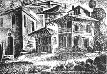
Angelos Theodoropoulos, Houses of Dimitsana
|
|
|
||
| Population (2001): | 1337 | ||
| Communes: | 7 | ||
| Elevation: | 944 m | ||
| Postal code: | 220 07 | ||
| Area/distance code: | 11-30-27950-3-4-85 (030-27950-3-4-85) | ||
| YPES: | 0506 | ||
| Car designation: | TP |
||
| 3-letter abbreviation: | DIM |
Angelos Theodoropoulos, Houses of Dimitsana
Until the 1960s, much of the town did not have electricity and until the 1980s, most of the houses were stone-built.

Communities

Population history
| Year | Communal Population | Municipal Population |
|---|---|---|
| 1981 | 760 | - |
| 1991 | 739 | 1529 |
| 2001 | 611 | 1337 |
| North: Lagkadia | ||
| West: Iraia |
Dimitsaina | East: Falanthos, Megalopoli |
| South: Gortyna, Trikolonoi |
|
Municipalities and communities of the Arcadia Prefecture Apollonas | Dimitsana | Falanthos | Falaisia | Gortyna | Iraia | Kleitor | Kontovazaina | Korythio | Lagkadia | Leonidio | Levidi | Mantineia | Megalopoli | North Kynouria | Skyritida | Tegea | Trikolonoi | Tripoli | Tropaia | Valtetsi | Vytina |
Retrieved from "http://en.wikipedia.org"
All text is available under the terms of the GNU Free Documentation License
|
Ancient Greece |
Medieval Greece / Byzantine Empire |
Modern Greece |
|---|---|---|
|
Science, Technology , Medicine , Warfare |
Science, Technology, Arts |
Cities, Islands, Regions, Fauna/Flora , |
