|
|
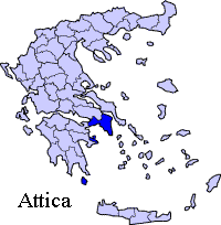
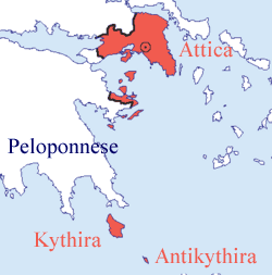
Kythira (Greek: , alternative spellings Kithira, Kythera, Cythera), also known as Cerigo (Τσιρίγο, alternative spelling Tsirigo) is an island of Greece, historically part of the Ionian Islands. It lies opposite the eastern tip of the Peloponnesos peninsula. It has an area of 284 km². The rugged terrain is a result of prevailing winds from the surrounding seas which have shaped its shores into steep rocky cliffs with deep bays. For many centuries, while naval travel was the only means for transportation, the island possessed a strategic location. Since the ancient times, until the mid 19th century, Kythira had been a crossroads of merchants, sailors, and conquerors. As such, it has had a long and varied history and has been influenced by a plethora of civilisations and cultures. This is reflected in its architecture (a blend of traditional, Aegean and Venetian elements), as well as the traditions and customs, influenced by centuries of coexistence of the Greek, Venetian and British civilisations as well as its numerous visitors. History At the start of the second millennium B.C. it was a Minoan colony and in 424 BC it came under the sway of Athens. In Ancient Greek Mythology, Kythira was considered to be the island of celestial Aphrodite, the Goddess of love, (cf. Cyprus, the island of Aphrodite). Over the centuries it knew a succession of conquerors from the Romans to the Byzantines, Venetians and Turks, and it was frequently looted by Barbary pirates. Kytherians still talk about the destruction and looting by Barbarossa, it has become an intrinsic part of the Kytherian folklore, yet one can easily accept the stories of locals by noticing the number of monasteries embedded in the rocky hillsides to avoid destruction by the pirates.
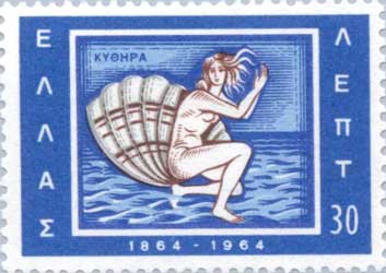
On the 21st of May 1864, the island was reunited with the, then young, Greek state. In the capital, Chora (or Kythira), inside the castle, one can find the Historical Archive of Kythira, the second largest in the Ionian islands, after the one found in Corfu. Kythira Today Like many of the smaller Aegean islands, Kythira is depopulated. While the island had reached a peak population of about 14,500 in 1864, that has steadily declined mostly due to emigration, both internal (to major urban centres of Greece) and external (to Australia, the United States, Germany) in the first half of the 20th century. Today its population hovers around 3,354 people (2001 census), but the modern Greek diaspora has produced around 60,000 Kytherian descendants in Australia alone. Kythira is administratively exceptional in that:
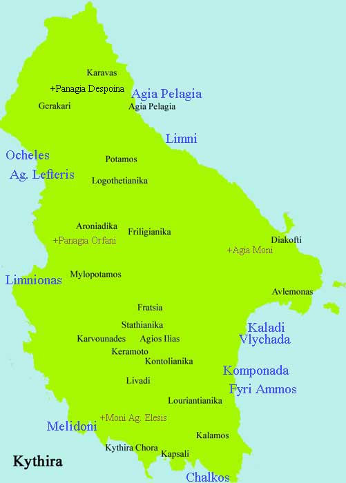
The island's main port Diakofti with the "island" Makronisi The capital - Chora - is located on the southern part of the island having no ports connected to the southern Peloponnese or Vatika. Kythira's port for Viatika is in Agia Pelagia Kythira. Most of the over 60 village names end with "-anika" and a few end with -athika, -iana and -ades. The island is close to the Hellenic-arc plate boundary, and thus, a highly seismogenic part of the region. Many earthquakes in recorded history have had their epicentres near or on the island. Probably the largest in recent times is the 1903 earthquake near at the village of Mitata, that caused significant damage as well as limited loss of life. At the beginning of the 21st century, two main earthquakes have been of concern: that of November 5, 2004, an earthquake measuring between 5.6 and 5.8 on the Richter scale and the earthquake of January 8, 2006, measuring 6.9ML. The epicenter of the latter was in the sea about 20km to the east of Kythira, at a depth of approximately 70km. Damage was caused to many buildings, particularly old ones, mostly in the village of Mitata, but there were no casualties. Due to its strength it was felt as far as Italy, Egypt and Jordan.
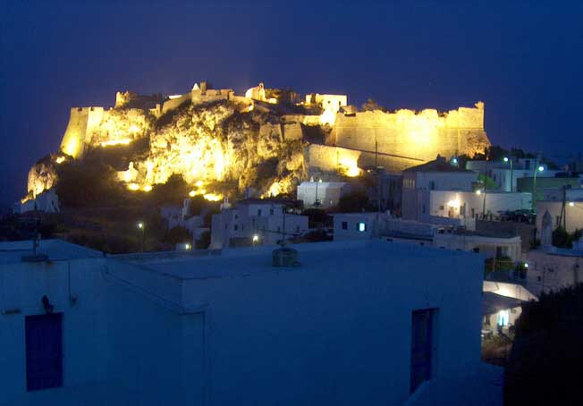
Kythira , Chora, Venetian Castle from the 16th century, inside the castle the church of Panagia Myrtidiotissa (Photo: Christos Makrozachopoulos) Despite the fact that the island has been a trade route for centuries, construction of a modern port was postponed several times until the latter half of the 20th century. In 1933, efforts were made to construct a port in the village of Agia Pelagia, yet internal, financial and governmental problems meant that it was only decades later that one was built. That small port of Agia Pelagia (now only serving smaller ferry boats from Neapolis - Vatika) was the island's main port until the mid-1990s. Around that time the new port of Diakofti, the site originally chosen by the island's British rulers in the 19th century, was constructed along with a modern wider road, aiming to support larger cargo and passenger vessels. The port of Diakofti currently serves scheduled routes to/from Gythion, Antikythira, Piraeus, Crete & Neapolis - Vatika. Additionally, the island has an airport, located in the region between the village of Friligiannika and Diakofti, about 8km from the capital. The airport was revamped and extended at the turn of the 21st century, largely by private funds provided by the local population. The island is served by Olympic Airlines flights.
Division of the municipality of Kythira, population 3354 (census 2001)
Agia Pelagia Kythira, Port In Katouni is the stonebridge of Katouni build 1829. Livadi it is becoming the business center of the island In Mylopotamos is the waterfall Fonissas Beaches: Kaladi , Chalkos, Fyri Ammos, Agia Pelagia and Melidoni.
 |
|
|||||||||||||||


|
|