- The official site of the Portaria Municipality
- Mt. Pelion through a series of original photohraphs and sketches
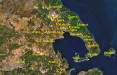
- Information about the prefecture of Magnesia, capital city of Volos and Mt. Pelion
- Portaria Village - Pelion Site dedicated to the mountainous village of Portaria, full of useful and practicle information
|
|
|
||||||||||||||||||||||||||||||||
| Location: Latitude: Longitude: |
39.384/39°23'4'' N. 23.9955/23°59'37'' E |
||||||||||||||||||||||||||||||||
| Population: (2001) |
3201 |
||||||||||||||||||||||||||||||||
| Elevation: -lowest: -centre: -highest: |
about 300 to 400 m 600 m(centre) about 1500 to 1800 m |
||||||||||||||||||||||||||||||||
| Postal code: | 370 11 | ||||||||||||||||||||||||||||||||
| Area/distance code: | 11-30-24280 (030-24280)-9 -99 for Portaria |
||||||||||||||||||||||||||||||||
| Municipal code: | 3719 | ||||||||||||||||||||||||||||||||
| Car designation: | BO |
||||||||||||||||||||||||||||||||
| 3-letter abbreviation: | POM Portaria Magnisias | ||||||||||||||||||||||||||||||||
| Website: | and its suburbs. It is also part of the Portaria municipality. The houses, its windows and its doors are painted beautifully with a variety of colors with beautifully colored edges. The mountaintop of Pelion is to the north. Portaria has a school, a lyceum, a gymnasium, banks, a post office and a square (plateia). Historical population
Neighboring localities
The municipality of Portaria, population 3201 (2001) is divided in
Links
 |
|
|||||||||||||||||||||||||||||||