Zagora

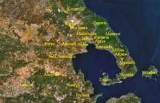
Location:
Latitude:
Longitude:

39.4445/39 °26'32' N.
23.0975/23 °5'53' E
Population: (2001) 3829
Elevation:
 -lowest:
 -centre:
 -highest:

Aegean Sea
458 m(centre)
about 1000 to 1500 m
Postal code: 370 01
Area/distance code: 11-30-24260 (030-24260)-2
Municipal code: 3710
Car designation: BO
3-letter abbreviation: ZGO Zagora
Website:

The Zagora municipality , population 3829 (2001), is divided in

  • Zagora / Δ.δ. Ζαγοράς [ 2582 ]
    • Zagora / η [ 2389 ]
    • Analipsi / η Ανάληψη [ 55 ]
    • Pourianos Stavros / ο [ 39 ]
    • Chorefto / το [ 99 ]
  • Makryrrachi / Δ.δ. Μακρυρράχης [ 663 ]
    • Makryrrachi / η Μακρυρράχη [ 602 ]
    • Agioi Saranta / οι Άγιοι Σαράντα [ 33 ]
    • Karavoma / το [ 28 ]
  • Pouri / Δ.δ. Πουρίου [ 584 ]
    • Pouri / το [ 538 ]
    • Elitsa / η Ελίτσα [ 12 ]
    • Ovrios / ο Οβριός [ 34 ]

Municipalities and communities of the Magnesia Prefecture

Afetes | Agria | Aisonia | Almyros | Alonnisos | Argalasti | Artemida | Feres | Iolkos | Karla | Milies | Mouresi | Nea Anchialos | Nea Ionia | Portaria | Pteleos | Sipiada | Skiathos | Skopelos | Sourpi | Volos | Zagora

Anavra | Keramidi | Makrinitsa | Trikeri

Retrieved from "http://en.wikipedia.org"
All text is available under the terms of the GNU Free Documentation License

A - B - C - D - E - F - G - H - I - J - K - L - M

N - O - P - Q - R - S - T - U - V - W - X - Y - Z