|
|
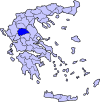
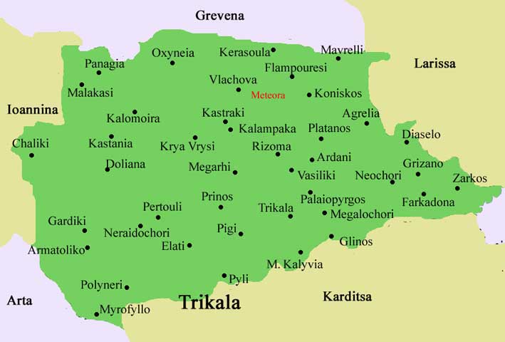
Pyli (Πύλη) is a municipality in the Trikala Prefecture, Greece. Population 4492 (2001) (including its municipal prefectures ). Situated 18km west of Trikala, right at the bottom of two mountains Itamos, and Koziakas, which mark the beginning of the Pindos mountainline, Pyli marks the entrance to a great gorge and the natural path that leads to the city of Arta. The river Portaikos runs through this location, and joins the river Lithaios, Trikala's major river and a side-river to river Pineios. The municipality of Pyli contains 6 municipal prefectures, but the town itself has a population of about 2,000. Most inhabitants are either self-employed in small business establishments or work in Trikala. Agriculture and animal herding as an occupation has been largely abandoned, though the surrounding area is ideal for both (mountainous and flat terrain). Pyli had always been the major trade center for the surrounding settlements and is full of interesting monuments and beautiful scenery.
An aerial photograph of the town of Pyli (*)
The settlement of Pyli has been referenced since antiquity. It is first mentioned in the work of Pausanias, Description of Greece (Hellados Periegesis), a travel and cultural guide of ancient Greece, referenced as "Great Gates", because the location is a natural passage between Epirus and Thessaly. There also was a temple devoted to Aphaia Athina in the surrounding area, whose ruins can be still seen. It is also recorded that Alexander the Great passed through Epirus and came to Thessaly through Pyli, in order to ensure Thessaly's support in his plans (which was succesfull, the cavalry of Thessaly became notorious in Alexander's campaign). It was also later revisited by King Philip V of Macedon. During the Greco-Roman times, the location was found to be of strategic importance and the castle of Athinaion was used as an outpost, enabling monitoring of the plains in distances of up to 30 or 40 km (the famous Meteora are visible on a clear day from these outposts). In Byzantine times, after the first fall of Constantinople in 1204 A.D., various independent feifs had emerged, one of the most notable being the Despotat of Mystra, which sovereigned over the whole of Epirus, Thessaly and most of Central Greece. During those times, one of the most notable churches of the era was constructed, the basilica of Porta Panagia. It was built on top of the ruins of an ancient temple (probably a temple dedicated to Apollo), a practice common at the times. Pieces of marble from the original temple can still be seen inside and outside of the church, and restoration of the original temple is practically impossible without destroying the church which in itself is of great cultural and historical value. Services are still held there but only on special occasions and holidays (for instance in the 23rd of August, on the occasion of Virgin Mary's ninth day memorial). In later days during the era under the rule of the Ottoman Empire, the town had prospered and while it had originally been situated in the north side of the river Portaikos, it is mentioned in the writings of Cosmas of Aetolia that he visited Pyli, and the residents gave no heed to his teachings. It is said that he cursed Pyli and its residents (then known as Porta), and they relocated to the south bank, where Pyli stands today. During the Ottoman era, Ali-Pasha, the Pasha of Ioannina, rebelled against the Ottoman Empire and tried to turn Epirus into an independent caliphate. During his campaign, his army camped briefly at Pyli, and lit a very large and venerable platanus, which was badly burnt, but survived due to its large and strong roots, and still survives to this day. During World War II, the area came under the authority of Italian occupation forces, and during the years 1943-1944 under German occupation forces, which set fire to the monastery of the Dormition of Theotokos, believing that rebel forces of the ELAS were in hiding there. In modern years, Pyli has been the local trading and education center for the surrounding villages and settlements, especially those situated in the mountainous area west of Pyli. Since Thessaly was merged into the Kingdom of Greece in 1888, Pyli was always intensely populated and bristling with activity, being characterized as a 'small town' and electing a mayor of its own. With the Kapodistrias enactement in the late 90s, Pyli officially became a municipality with 6 municipal prefectures under its jurisdiction, St. Vissarion, Ropoto, Palaiokarya, Petrohori, St. Prokopios and Kotroni.
A view of Pyli and Dousiko from the mountain of Itamos (*) Monuments A place of great historic importance due mainly to its strategic location as well its unique landscape, Pyli boasts a large number of monuments, especially considering its size.
The basilica of Porta Panagia today (*)
The monastery St. Vissarion as seen from the east face (*)
The arched bridge of Pyli (known as Kamara) (*)
Climate The climate in Pyli is worth mentioning since it has characteristics of both the plains and the mountainous regions of Thessaly. It is generally wet in the winter, with regular snowfalls each year averaging 30-40cm of snow. There are also frequent rains, and low temperatures. In the summer it is arid and hot, though there are occasional buffs of cool breezes coming from the mountains. The surrounding forests and the river foliage of platanus trees provide small pockets of relief in the summer, so Pyli is a favourite stopover for many people from Trikala and the surrounding villages who are in search of some shade. Facilities Pyli though being a small town has all the amenities one could ask for. Two major banks have branches there (National Bank of Greece, ATE Bank), there is a post office, a Health Center (a small healthcare facility with doctors on standby for emergencies), a fire department, an OTE local branch, pharmacies, super markets & mini marts, a large clothing store, as well as a couple of Internet Cafes. There's a multitude of small shops and generally all everyday needs are well catered for. Lodging Lodging in Pyli is provided by two hotels, Hotel Pyli (on the north bank of Portaikos), and Hotel Babanara (in the center of Pyli). The total amount of beds is about 100, and though in the winter it is generally easy to find a room, it is good practice to book in advance in the summer, since there are many regular visitors in the past few years. Both hotels offer good lodging in quite low prices. Entertainment Being a local center Pyli attracts quite a lot of people from neighbouring villages, settlements and its municipal prefectures. Thus, it has quite a few cafes that turn into night clubs in the evening, and actually even cater to specific tastes. Art Cafe is a modern, stylish cafe located right in the center of Pyli, playing casual pop hits, and a mixed selection of dance hits in the evening. Sfentona is a rock cafe, situated in the central pedestrian street of Pyli, where you can listen to classic and new wave rock favorites. Cafe La Porta opposite the City Hall is noted for its loud music and dance club atmosphere at night time, but also offers a nice view of the main road during coffee hour. There are also nice places to eat out, like Xagiati, Strofilia and the rustic Xantziaras situated right beside the venerable platanus tree, which signifies the old center of Pyli. There are also smaller, harder to notice places that usually cater to the needs of regular old-timers. Located on the borders of Pyli are also Tzaki, a family owned and run restaurant with a home environment and quite a large yard, Club Neromylos situated in the ruins of an old family watermill, with running water and small canals forming its environment, under a canopy of platanus trees that provide the best shade for miles, literally. Right beside the arched bridge, you can also find two other cafes with a great view of the bridge and the encircling mountains, as well as access to the now tranquil riverbed, soon to be devoid of water to the Acheloos redirection, a major irrigation public work for Thessaly, which is nearing completion. Pyli with its convenient location is also a preferable stopover for those who wish to continue on to the mountainous areas of Pindos, visit Elati (locally known as Tyrna) and the snow center at Pertouli, hike in the ranges of Vlaha, and generally pass to Epirus. It also offers easy access to Trikala, where an even larger multitude of entertainment opportunities can be found. Transportation There are regular buses almost every hour from and to Trikala, and you can also get tickets from and to Pyli directly from either Athens or Thessaloniki. Buses also provide access to the surrounding areas quite frequently (at least once a day), and there is a local cab service available. Division of the municipality of Pyli
Sports There is a mountaineering club that organizes hikes and trips to mountains all over Greece, as well as rock climbing in the encircling mountain cliffs. Links
(*) Image Sources http://www.dimospylis.gr/ References
See also Pyli, Dervenochori, Viotia
 |
|
|||||||||||||||


|
|