|
|
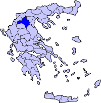
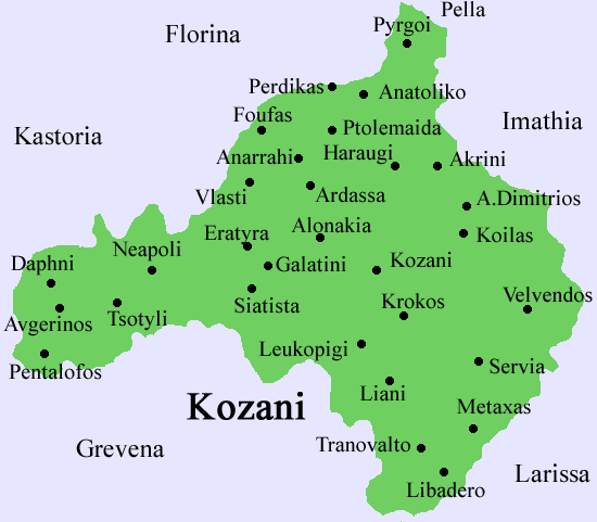
The Municipality of Vermio (Greek: Βέρμιο) lies in Western Macedonia, Greece Total population: 3483 permanent inhabitants(2001) About the municipality: The municipality of Vermio consists of four municipal departments; Komnina which is the largest and the seat of Vermio's town hall, Anatoliko, Pyrghi and Mesovouno. It lies between the prefectures of Kozani, Florina and Pella. Its administration belongs to the prefecture of Kozani, in the region of Western Macedonia, Greece. The majority of the population is Christian Orthodox with some tiny minorities of atheists or other beliefs. Visitors can found several churches everywhere (Orthodox only) and the ecclesiastical administration of Vermio belongs to the holy diocense of Florina. History The existence of life since 100.000 BC testifies a lot of discoveries from Paleolithic and Neolithic age in the entire prefecture Kozani. At the first-Greek period (2200-1150 BC) in the Municipality of Vermio lived the first Greeks (Iones, Arcadians and first Aeolian tribes). Later, a big part of this tribe emigrated in Peloponnesus, in the Thessaly and in Solid Greece. Still, in the locality lived various Thracian tribes. According to the archaeological discoveries and the historical testimonies at the archaic age (1100-479 BC) the Municipality of Vermio it is lived by the Greek-speaking team of Macedonians, that are installed successively in the provinces of Pieria and Almopia of (current Aridea). Then, they elapsed Axios and approach the limits of Chalkidiki. In Eordea lived the Thracian tribes Eordeans and in locality Vermios in Votiea, the Votiei, that were little by little forced to succumb in the Macedonians or to install itself in other parts of Macedonia. Ginos Dimitrios (schoolteacher with 20 year service in the school of Towers and author of Museum of school), in his article ‘’TOWERS of EORDEA - a village with history ", periodical Fanari (Lantern), reports: "The ancient city Eordea at the historical Dimtsas was maintained prosperous up to the 10th century therefore were destroyed completely by the Bulgarians and are not reported from later authors.” During the Persian wars, Eordeans called, took part in the expedition against Persians (Herodotus. ' Z '. 185). During the Peloponnesian war in Eordea encamped the heroic king of Sparta Brasidas (424 BC) as ally of king of Macedonia Perdikkas the Second and fought against the king of Lygkists Arriveos (Thucydides B’99) untying by treaty, their conflict. The new discoveries of archaeology in combination with linguistic analyses and the recovery many new signs - all Greek - with rich sample book of Greek names prove that does not exist interruption, neither cultural nor linguistic, unit of Macedonians with the remainder Greeks. Besides the distribution of Greek language and Greek culture in whole the known world from the Macedonians of Alexander the Great it constitutes the most verbal confirmation of this fact. A fact that is ratified each time from the new archaeological discoveries that come in light, or in the big excavations of Pella, Vergina, the Dios and Sindos, or in tens least acquaintances, as in the locations Viou, Kozani, Kastoria, Florina, Edessa, Aridea, Kilkis, Kavala, Thessalonica, Chalkidiki and of course the Municipality Vermios in apartments of Towers. In the classic age of Alexander the Great, the Municipality Vermios offered in the Macedonian army brave warriors that constituted big percentage of eminent Macedonian column and for a lot of centuries our Municipality was the centre of Greek culture and the rock above in which smashed the uncounted crowds of barbarians from legendary javelin and Macedonian sword. The tradition reports that Ptolemy (Ptolemaios), the general of Alexander the Great was from the Apartment of Towers, along of was capital of Eordea, because Ptolemy was Eordean from upper Macedonia. Eordea as province of, at that time, big and glorious Macedonian state is eligible the hoop of glory. Macedons, with leader Ptolemeos, took part in the gracious campaign of legendary Macedonian conqueror Alexander the Great. From the book of George Kitsopoulos " Alexander The Great ", volume third, we take the following cells as probative for the role that played Ptolemy in the burial of Alexander The Great: '...The wish of Alexander The Great was always to burry him near to Ifestionas, in Alexandria. And this wish of him, Ptolemeos, when he accepted to undertake the hegemony of Egypt, had it in deeply in mind. The presence of Alexander the Great grave would be a support for the dynasty that counted to install in the country of Nile. As guardians of Alexander the Great grave would be himself and his successors, from the entire world respectable. Perdikkas however drifted from the old Macedonian grave, that fixed that all the kings of Macedonia should buried at “Eges”, or because had required it Olympiada, that had resorted to the Continent and had with him continuous contact, appeared hesitant and showed rather decided to send the procession to the northern, to elapse Ellispontos. With other reasons he was ready to make opposite from that initially they had been agreed. It appears, therefore that round this direction of funereal procession, if it would go to Pella, or were in Alexandria, it burst out, few days before the funeral, a new conflict. And in this took part, because they had not begun for their provinces, all the big bodyguards and the generals. Ptolemy was supported by the wish of Alexander that was well known. While Perdikkas insisted that it should not with no way to interrupt the ancient tradition, because then Macedonian state was in danger to resolve... Ptolemy gained the game, with a proposal supposed to be accommodating, according to which Alexander would not have his grave in Alexandria, but Ptolemy would bury him in oasis of Siva, in the Temple of Ammon. As writes Diodoros, Ptolemy that was ahead, came out with his army in Syria, in order to meet the funereal procession and received the mortal remains. However he did not keep the promise that he had given. It judged better to bury Alexander The Great in Alexandria, in a tomb worthy of his glory, brilliant and big. According to Diodoros, Ptolemy deposit the golden carnivorous in a gorgeous monument of Alexandria, and followed in the burial the Macedonian customs...’ Ptolemy after the death of Alexander the Great (323 BC) took part in the succession. In 316 BC he took as share Egypt and was named king. Apart from his martial activities, was important his work and in the interior of state (administrative reforms, economic meters etc). He founded the Museum and the Library of Alexandria and generally protected the letters and the arts. He embellished Alexandria with beautiful buildings and temples. He wrote various books, as the chronicle of expedition of Alexander the Great. During the Roman time, Macedonia, after the defeat of Perseus in the battle of Pydna, passed in the power of Romans. The headless statuette of about biennial child, work of Roman times that was found in the Apartment Mesovounou squeals the subjection of Macedonians to Romans. According to history, despite Macedonians find themselves under Roman sovereignty, the Macedonian provinces thrive and the Roman settlers by degrees Hellenized linguistic. " For Eordea indication and between Romans and Macedonians wars until and during times of Macedonian sovereignty of Romans, then belongs to the western department of Roman Macedonia, because this was crossed the Egnatia Road, connecting Rome afterwards the tributary to this of East countries". A cupreous seal with circular handhold that was found in the Municipal Apartment Pyrgi is dated since Roman times. It’s about seal of tiles or bricks. Similar seals were also used for the sealing of breads. During 3rd century BC were marked successive raids of Goths and other relative tribes. But they repulse without any ethnical alterations. In 324 AD Capital of Roman state is transported at Byzantium, make that influences positively the further growth of Macedonia and particularly the capital of Thessalonica, which is gradually developed in such point, so that it constitutes the second in importance city of Byzantine Empire. It should, finally, marked that Macedonia existed as the main gate for the entry of Christianity in our continent. As we remember the vision of Apostle Paul that night at Troada, judged the later course of Europe: was presented to Paul and with insistence requested: "Passage to Macedonia will help us” (Acts 16, 8-9). It is characteristic that the Apostle of Nations, addressing to Macedonians, declared the reason of god and wrote his pastoral epistle in Greek. Division of the municipality
Head department of Komnina
In their Northeastern foot of overgrown mountain “Mavro Pouli” (Black Bird) is built on Komnina, the seat of Municipality of Vermio. Big building activity is observed here. In the square of village exists a splendid park with Monument of the fallen and the Municipal School. Abundant and cold is the waters, rich the vegetation and healthy the climate of place. Big irrigation dam improved the attribution of cultures. Cereals, clovers, tobaccos and veterinary surgeon products produce abundantly the band. A lot of executed work beneficial to the public improved considerably the biotic and cultural level of residents, refugees’ residents from villages of Trabzon, Pontus and Nigde, Anatolia. Archaeological discoveries (The name was given from its residents, who considered to be descendants of Emperors Komninos of Trapezounta(Trabzon) and who came here as refugees from Pontus with the exchange of populations) 1. In the top of mountain "Mavro Pouli" finds itself small cave, that brings the name "Crypt of Kara - Ali'". 2. Traces of walls of two fortresses and settlement exist in the locality Komninos. The first in the hill DELTA and the second in Ovon (conning hill of southern Apartment). Their existence is testified by objects, that were found older, as: shells of vessels, cupreous currencies, base of pillar, various marbles from buildings, two rings made of glass, small cupbearer of Byzantine times and marble bas-relief, in which pictured a feminine form with tunic, with helmet, spear and shield. 3. Eastern of the Apartment is extended the mount Vermio. Between this and the mountain "Mavro Pouli" takes shape alley. The physics diode, that it goes through via this, leads from the Eordea to old Egnatia Road to the locality Edessa of - Towers - Komninos - Ptolemaida, as shorter, they followed at the times of Ottoman domination ships of tradesmen for the distribution of products Municipal department of Anatoliko
The residents refugees from Minoa Asia founded the municipal part in 1923 and later worked with zeal, insistence and patience in order to alter the ruins, that Turks had left. Their industry changed radically the aspect of place. Its streets are big, turnpike and spotless. The houses are new and tidied up. The square is beautiful and illuminated at night. A marvelous park and the monument of fallen are found in the Centre of Municipal Apartment, as well as a lot of public and territorial new shops. Tobacco and the cereals are the main produced products that contribute in the economic progress and development of Municipal Apartment. The redistribution of plots, the water from drillings and the irrigation networks of cooperative helped the residents to work with better terms and to produce more products. Archaeoligical discoveries (The refugees’ residents that installed here afterwards the Minor Asia Catastrophe named it “Anatoliko” (Eastern) wishing the east a better and happy life in the free Homeland). 1. An old settlement was found of 150 acres in the locality "Megali Spilia" (Big cave) of Vermio, where found themselves shells of vessels and tiles. 2. In the location "Patates" (Potatoes) were found by residents graves, earthen objects and an arrow. 3. In distance 500m to the street of Saint Christopher, in year 1967 were found boxy graves with earthen vessels, that by ignorance were destroyed, currencies of Alexander The Great, Thessalonica’s and other objects they are found in this locality. Municipal department of Pyrighi
Big trees of white and sycamore cover the banks of Aspropotamos that cross the small valley. Clovers and fruiter trees frame the landscape. Systematically it is the culture of apple tree and peach tree. The production of apples amounts in thousands tones annually. It is also important the yield in cereals, tobaccos and veterinary surgeon products. In the verdurous landscape of small valley appear the beautiful newly built houses, the public shops, the historical temples and the monuments of Apartment of Towers. Beautiful and protected from the winds locality, abundant waters from the sources of Vermio and the healthy climate they created most important pole from the ancient years. With the exchange of populations, in the place of Mohammedan residents came refugees from Sevastia, Smyrna, Constantinople, Trapezounta (Trabzon) of Pontus. Monument of fallen from the German troops of possession also exists also in this Apartment, that reminds the place of sacrifice of innocent victims hysteric tragedy. Archaeoligical discoveries (King of Castles {Castle-Άnassa}, was considered at legend. At other version of local tradition was named Castle of Agnitsis, to honor the daughter of Citadel. Sovereign from the conjunction and corruption of the words "Castle Άnassas" or "Castle Agnitsis" emanated the name Katranitsa or Kastranissa. We had also in this Apartment installation of Native of the Pont refugees with the exchange of populations). 1. Traces of tower (Castle) were found on small hill (Citadel) with two fortresses, phylactery narrow crossing from the Egnatia road to Eordea and shelters of his residents. This Citadel was most powerful than the fortresses of diode also in the first line of Eordea’s defense at the ancient ages. In the second fortification line of defense the fortress of Mesovouni is found and in third the fortresses of Komninos. The location of the Castle is named "Gkrat". It is extent roughly 500,000 square meters and is found in the N.W. of current Municipal Apartment. Near to the Castle is found "Politsa", a basin 3,000 square meters that was overgrown with vines. According to the tradition at the siege of city Eordea from Samouil and while the Bulgarians (after the betrayal of a woman) located and destroyed the conductor of water feeder, the residents bore in the Citadel (Castle) eight (8) months drinking instead of water wine from the big quantities that they had in the cellars. 2. In the Castle exists stone built bridge that linked the village with Grammatico. This bridge is named "GKELIN MOST", that means Turkish bride. As the tradition says, it took its name from the girl of a Turk, sovereign of place, which passed bride on horse from the bridge and bent to see the water, however she lost her balance and fell in. 3. A vaulted stone bridge is saved at the N.W. of the Castle. The name of the bridge is "SANTRI MOST". Remains of paved street begin from the entry of the Castle and end at village Vegora near Vegoritida Lake, where exist relic of ancient settlement. At legend, the sovereign of Vegora asked in marriage the girl of sovereign of Castle of Katranitsas. The proposal became acceptable and the paved street was manufactured in order to passes on chariots the nuptial procession and they communicate 4. The existence of Bishopric of Towers in the frames Moglen’s Metropolis, which is interwoven with Roman and Byzantine geographic subjects in Macedonia, implies the ecclesiastical book of Holy Abbey of Virgin Mary Driovounou, where are reported the followings: "The authority where killed the Cashier of sacrosanct of Bishopric of Katranitsas Kyrpoy Prohorou year of 1739 April 17 " 5. The carpet of flooring of palace was located from the unforgettable archaeologist professor Keramopoulo with George Liampas, with the clue of Hercules with lion's hide in mosaic of good situation. (Chronology 2nd – 3rd century) In the excavation on 1939 department of mosaic flooring was revealed, pale Christian temple, from the archaeologist Kotzias. 6. Near in the citadel the foundries were found. This is also confirmed by the researches that the Germans made at 1943. They examined the ashes in order to find the by-product of noble metal. 7. Thesis of Archaeologist Angeliki Konstantinopoulou: In the place "Carsija Crkva", 4 km of village, paleochristian royal church with arch was discovered. Still was found seal round with the sign: "Inland Revenue of en Katranitsi of Greek Schools used at the Ottoman domination". 8. On 26/7/1995 (Archaeologist Mrs. Karamitrou) one-chambered Macedonian grave was found despoiled from the antiquity, likely 4th century BC, with dimensions of booth internal (2,83 x 2,85 m.) and facade of simple width of 3,25 m. The monument is the second one of this type in Eordea, afterwards the monumental in facade and not looted from the antiquity grave in the village Cave. Similar grave appear that it was destroyed the passed century in Liknades of Voios, by which departments of marble gate have been rescued in Tsotili. These monuments are important because they show the unit of classes’ customs of Upper Macedonia concerning Down Macedonia as well as the high biotic and cultural level of band of (Upper Macedonia), for which the systematic excavations proved that it was not isolated culturally and socially. 9. On 26/7/1995 they were also found, ancient city in the place Castle, places with smaller settlements, place with public building and Dorian capital, cottages and cemeteries, from which vessels are emanated, that are dated in the season of Iron, in the ancient, classic, Hellenistic, Roman and Byzantine years, signs and between them boundary sign with quoted the cities Vokeria, Keli and Dolihi, department of marble bas-relief from the city Castle with representation of feminine form, the representative all discoveries of all historical periods uninterruptedly from the prehistoric years with acne and in ancient and classic years (before Philip and Alexander). The discoveries that came in the light, presuppose very precociously organized urban life and vigorous economy, testify culture that includes the band in cultural common the remainder southern Hellenism. 10.On 8/8/1995 stone leaf was also found, right the entry of Macedonian grave, as also discoveries, as: crockery flowers, fruits and cupreous leaves from wreath, department of glass alabaster, crockeries Attica pelyc red-colored with representation of woman, iron scraper, earthen bonnet, iron unsolved objects, cupreous bucket, cupreous circular, cupreous cupbearer, iron peak of spear and three earthen vessels, red-colored sac, bonnet and salt vase. By this grave the growth of metalworking is confirmed as in each corner of Macedonian ground, the commercial exchanges and the cultural identity of space that belongs in ancient northern Eordea, which with the kingdoms of Elimiotidas (with capital the systematically digging up Aiani), Tymfaia (location Grevena), Orestida (location Kastoria), Ligistida (location Florina), Deriopo and Pelagonia (except the Greek borders) constituted the upper Macedonia of ancient (acquaintance from the Herodotus, Thucydides, Stravonas and other Municipal department of Mesovouno
The mountainous locality, suitable for pasturage of goats, presents interest for the hunters of hare and partridge. Farmer-breeders are Pont's inhabitants from the German troops of possession are witness of her residents’ heroes. (It is built in the means of mountain and installed s this Native of the Pontian refugees with the exchange of populations after the Minor Asia Catastrophe). 1. Ruins of temple and graves with vessels discovered near to the current cemetery. 2. Traces of ancient fortress exist in place "GALAS". This fortress espies the crossing that passes from the alley of Komninos. 3. Were found headless statuette, about biennial child, work of Roman years and copy from older Hellenistic model (Museum Kozani). The statuette appears that it was tomb monument, placed in the grave of small child.
 |
|
|||||||||||||