- Mapquest - Varda, no street map available
- traveljournals.net - Varda
Vouprasia (Greek: Βουπρασία) is a municipality in the Elis Prefecture, Greece. Its seat of administration is Varda (Βάρδα), a small town with a population of 3100 (2001) It's located between the highway that stretches from Pyrgos (Ilia) to Patras and Athens via GR-9/E55. Vouprasia was named after the ancient city if Vouprasia (Bouprasium). Mentioned by Homer in the catalog of ships Book 2: Soldiers from Bouprasium, fair Elis, those parts In 1316 there was a battle near Varda between Catalans and Greek forces The Catalans lost their leader was killer. The municipality of Vouprasia was first formed from 20 April 1835 (population 379) until 1911. In this period various villages were added to the municipality. In 1849 Manolada was the seat of the municipality. Geography Its location is on a hilltop. Other areas away from the train tracks remains flat. The town has a river to its east. A health center, which is also serves like a rural hospital is founded southwest of the downtown core. Lying between the train tracks. It serves Kyllini, parts of Andravida Lechaina and Varda, cities that are near to this health center. The town also has a railroad station. Its speed limit on non-national roads is 40 to 50 km/h and 30 to 40 km/n on Movri mountain range. Its road condition were poor in the past. They are nearly in the excellent (A-plus or a+) level in the 21st century. Scenery of grassy Mount Movri and rocky Mount Scollis which is partly hidden near Vouprasia, and Kalogria and some prefer Lappa. is seen anywhere. Not far from Aghios Nikolaos monastery, the coast of Kyllini can be seen, along with Cephallonia/Cephallenia, Zante, Ithaca, and central Ilia. There are now two, some prefer three active railroad crossings in the municipality, the remainder are not electrically operated. Tens of greenhouses are scattered mainly above sea level. They are founded mainly east of GR-9, or E55. It was built in the 1980s. There are one humongous greenhouse off the BP gas bar. width is almost 150 m and the length is exactly 700 to 800 m. There are other greenhouses scattered in Psari, east of Manoláda, Magoúla, Apiedona, and one SE of New Vourási(on). There are tens of barns scattered mainly above sea lever by 3 m, and east of GR-9 as well. Green Forest are located south of Várda and Manoláda. and further north of Varda. Forests in Várda and Manoláda dominate in the valleys and 2 km² of land. Nea Manolada is a town northeast of Varda via the GR-9. There is only one road connecting the two parts. Not the four other sidewalks on railroad crossings. Its railroad station is modeled like a kiosk. It has no shelter, and has benches. The field in front of the streets and in the middle of the tracks is completely covered with green grass. A city square, and a school are lined up on this main street that has no name, but a highway number, GR-9, the old (inter)state highway. Approxinately five streets are lined up almost due southwest to northeast, and eight are lined up form southeast to northwest. There is a road connecting Manoláda, Kounoupéli, and Kalógria on Manolada's northwest side. There are about 200 buildings, 100 poles, and thousands of trees, which New Manoláda is almost surrounded with. A creek is neighboring to the south, and Larissos river is bordered to the north.
Population history Year Communal Population Population 1981 3039 Division of the municipality (population 11204 in 2001)
Agriculture Agriculture used to be the leading source of industry until the 1980s, eroded by non-agricultural industry by outlets, stores, and some markets Links
Municipality of Vouprasias
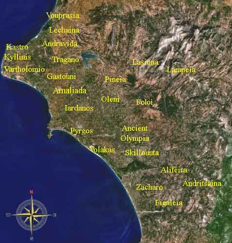
There are about 13 kilometres of sandy coastlines in the municipality, including the easter part of the lagoon named Kotychi. There are rivers running in the municipality. About 40% of the rivers are not dry. Only its creek and streams (the remainder) are almost dry that it cannot flow into the bay. The first train tracks and railway stations opened in 1900s. There are three, some prefer four train stations, one is in the outdoors, and the rest are indoors. The municipality formerly included Mataranga and Spata. In the late-20th century, these areas were reverted to Larissos and to the prefecture of Achaia. The list of villages and communities are:
Psari Psari (older Form Psarion) is a settlement / village of Vouprasia, (38°1'25 N, 21°23'17 O) Year Population Aetorrachi Aetorrachi is a village known in the past as Valaka. It was named after a Turk, Valak Agas who was the owner of the region. After the liberation a village formed from population coming from Kandalo Skoupi and Karousa from the region in Kalavryta. In the summer of 1957 it was renamed to Aetorrachi. It was a community with Koumouthreka (or Kumuthreka, which was renamed to Dafni). Due to the Kapodistrias plan the community does not exist anymore, Aetorrachi and Dafni are now part of the Vouprasia municipality. Aetorrachi is near a lake formed by the Pineios river.
Retrieved from "http://en.wikipedia.org"
![]() |
|
|||||||||||||||||||||||||||||||||||||||||||||||||||||||||||