|
|
|
||
| Population (2001): | 6334 | ||
| Elevation: | about 5 m (centre) | ||
| Postal code: | 270 53 | ||
| Area/distance code: | 11-30-26230-3 (030-26230-3) | ||
| Municipal code: | 1715 | ||
| Car designation: | HA |
||
| Name of inhabitants: | Lechainiti m, -ssa f or Leheniti m, -ssa f · |
||
| Address of administration: | 2 Polytechneiou St. Lechaina 270 53 |
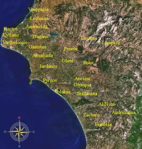
Lechainá (Greek; Λεχαινά), also Lechena or Lehena is a town in the Prefecture of Ilia, Greece that is 39 km N (old distance: 37 km) north of the nearby city of Pyrgos and regions of Messenia and Arcadia. It is also located far west of Athens, Greece and 60 km SW (old distance: 61 km) southwest of Patras. As of 2003, its population was around 3,300. The dialing code for the region is 30 followed by 26230 with five-digit numbers. Half of the stores and markets line Lechaina's two main streets.
Geography, features, and information
Latitude is 37.93° or 37° 54′ north and longitude is exactly 21.27° or 21° 15′ east. The elevation is between 4 and 5 meters (17 feet) above sea level. Areas along the beachside remains at sea level. The highest point is around 20 metres (around 70 feet) to 50 metres (160 feet). The length of the community coastline is around 3 kilometers. Originally a few meters less before construction workers raised the land by 10 m prior to the mid-20th century. The length of the roads is 30 to 35 km in total. Fifteen km is paved, including 8 km of federal roads old and new. Two km of residential streets, and the remainder is surfaced. Its nearest health centre is 14 kilometers northeast outside Lechaina (originally 17 km). The nearest hospital is 21 kilometers southeast in Amalias. The nearest major port is Kyllini, 10 km. east (originally 13 km from the centre.) The community area has three stations. A post office is found near the centre of town. Before the 1960s, stone roads were common and only found in Lechaina. The only paved road that exist in the period was on the National Road/Highway in the 1960s before construction began to expand paved roads to the whole area. The average town's maximum speed limit is 20 km/h on narrowest streets, 30 km/h on other streets, 50 km/h on its roads (except national roads).

There is a local λαϊκή, laikí happening most of the weekends near Karkavitsas Street. The market is small and only fifty meters long.
An international festival took place from late-July to around mid-August with concert, shows, and festivities.
To its northwest, the beach still known as Lechaina Beach today, has a view of the Ionian Islands. They are Cephallonia by Mount Aenos or Ainos; its island chain including Ithaca. The Northern half of the island of Zante can be seen, because a hill which overlooks Chlemoutsi and Kyllene is blocking the southern half of the island. And the land of Aetoloacarnania to the northeast. Distance to Cephallonia (without ferry) is around 40 km, and to nearest point on Aetolia is 30 km.
The beaches north of Lechaina are Lechaina Beach, and Panorama Beach, which has a lot of summer homes and a restaurant, also known to some tourists. And one near the lagoon of Kotychi. It even has an abandoned soccer field which was reopened without turf. Two pristine restaurants are located there. One that has a sandy parking lot. The other has a road beside that restaurant.
Camp Lechaina (spelt Lehena before the 1990s) was a big campsite for Northern Elia (Elea). Shut down in the late 1990s because another campsite on Myrsini Beach was open for business. The East campsite is named Green Camp is founded directly north. It was also the same business, both built near green forests and blue-water beaches built around the periphery. A factory slightly to the northeast is named "Robico".
Not far from the camp are fertile flat unhabited plains with farmlands that stretch from outside the municipal boundaries ending up near thalassa 'the sea' with coastline. The size is about ten km². A creek named Andravida flows in the middle. Peneus River used to flow on what is now Andravida creek in ancient times and was a swamp region. Some torrential weather or a drought changed the course of the river to the Palaiochori. The swamp was drained to make room for farmland. Today only marshes are left next of Aghios Panteleimonos beach marking the original swampy wetlands, which used to cover 100 m. by 1 km. 8 to 10 km². Many of the houses on Lechaina's north side are close to the forest, but there is one abandoned house and one closed-down building lying in the plains, with no trees. Trees are found mainly near irrigation canals in that area.
The water emptying into the sea is somewhere between 100s of m³ to none durimg Summer weather. Andravida's output during summer months is nearly 6 to 12 m³ every flow, hundreds to thousands every day.
Kotinaiika and Aghios Athanasios (Saint Athanasius) has only about five houses. Tens of people live in that area. Surrounded almost entirely by trees, a small Aghios Athanasios church is founded. Seating only numbers ten to twenty. The actual size is small making one of the smallest churches in the Lechaina area.
An outdoor theatre playing movies is not far from the centre. It is located at Polytechneíou, one block east of Papaphléstreets. A pub located one block north of Papaphléssa Street on Karkavítsas Street is a pub operated from the early 1990s to 1999 or 2000 is Johnnie Fun. The size is small, about 60 to 80 m².
Aghios Demetrios, a square which includes a church is located in the heart of town. Other squares are located near Myrsini Road and Efzonon, and another one near Al. Mastrovassilis Street. There are two kiosks, a bus stop, a taxi stand, restaurant, bar, and trees standing west. There are two divided streets, one that exist and one that has been converted into a walkway. The city has exactly two walkways, one in the east, and the other completed in the mid-1990s and expanded in the early-2000s with outdoor patios and restaurants. Its main streets are Polytechneiou and Ethniki Antistatheos Streets, even Myrsini Road. Papaflessa Street is no longer considered a main street to the beach because the municipality were turning the street into a walkway to decrease and remove the traffic flow and make it usable to pedestrians. A post office is founded somewhere in the town centre, founded in the mid-20th century.
Lechaina has a railroad station in the east. Two railway tracks run past the station. Lechaina has one highschool, and a school near the road that connects the beach and Lechaina.
East of Lechaina, there is a milk factory operated by Delta, and a famous mud-water moschoneri right near the junction of Old Road and road to Melissa (Elia) and Borsi. People come to soothe the body in black mud. Others think it was fun playing in rich dark mud. Another factory is found north of the military airport. A village named Mélissa (from the bees)is to the east, the original name used to be and some still say the name that is no longer named, Zonga (Ζόγκα). The village changed its name somewhere in the 1800s. Its population has been stabily growing. The population reached 300 in the latter part of the 20th century.
There are around 5 to 7 railroad crossings in town and the municipality, two with electrical barriers, with flashing red lights when the train is approaching. (One in Arete, and one put up at the beginning of the 2000s in Lechaina, otherwise they were put down, the old-fashioned way.) Others has no railroad barriers.
The principal rivers are Andravida Creek, and Melissos.
Electricity is powered from Andravida to Varda of Lappa by a power generation station located close to 1 kilometer on Myrsini Road.
Alongside is a little village made up of poorly-built old-generation-style houses, and poor income only in a range of .15 square kilometers.
Little hamlets of Kotinaiika and Veskoukaiika are nearly covered with forests slightly north of Lechaina.
Luxurious houses are built in Lechaina's west side. A number of luxurious homes lined up with the ditchy dangerous irrigation canal.
A small hamlet to the east is Veskoukaiika. The population is about 18, and never reached above 20. The commune size is only 1 km². 1 to 1.5 kilometres of phone line installed beside the stony agricultural road. A few tall pine trees and bamboo sticks are lined to its NW at a road connecting Lechaina area to Veskoukaiika. East, a road connects Green Camp, and the Kotychi Wetlands. From a road viewing from the west Veskoukaiika cannot be seen because it is covered with groves which dominate land slightly north of the hamlet. Groves again cover east of the small tiny hamlet. Almost 60 to 75% of Veskoukaiika is covered with groves and olive trees. Couple of pine trees lie about 1 km east. There was only one house lying during the 1000s and the mid-1000s, known to some sources. The community has been poor before the 1960s. The population has been decreasing, because jobs are found in Lechaina. The population probably had include some minority groups like the Gypsies. There are about 100 to 200 gypsies lying throughout the municipality. Since the 1990s it has been only a visiting spot for summer.
At night lights from the villages especially Riolos can be seen from Lechaina Beach. And even the village of Elis can also be seen. From Borsi, a view of Kentro, Aghioi Demetrios of Elis, Gastouni and southern villages and towns of Southern Kyllini can also be seen. From Melissa of Lechaina, a view of the valley with farms and Borsi is viewed. Mount Scollis and Movri Ranges can be seen anywhere in the area of Lechaina, except for the valleys. During the day, the panorama from Borsi features the Erymanth(u)os/Olonos ranges, the Pholoe mountain range, the Peneus valley and the southern tip of the peninsula of Kyllini is also seen south of the village, especially ancient Elis. Lights from the surrounding village of the southern coast are glowing into the night sky to the municipal boundary. The view of mount Erymanthus or Olonos can only be seen mostly in Lechaina's west side, partial from Aghioi Theodoroi and Melissa, and none east of the Aetorrhache area and even into Borsi and Mount Scollis.
There were 2 Texaco gas stations, one near the junction which is now dominated by Epsilon-Pi, and the other is no longer using the name Texaco, Shell has taken over at the 56th km mark of Patras-Pyrgos Highway. One other factory is also in the NE near where 4 to 5 logs are placed on a surfaced road adjacent to the train tracks and GR-9.
Its famous person that lived in Lechania is Andreas Karkavitsas. A street is named Karkavítsas Street (Οδός Καρκαβίτσας Odos Karkavitsas) in honor of him. His house where he used to live is located on the south end of the street, along with the statue.
Before the 1960s and 1970s, almost all homes were poorly built with stone and wood. Almost the entire section of houses in the city had no hydro, telephone, and some had no water. Around 30 to 40% of these stone-built houses survive in the present day. Safer houses that are made mostly out of granite took over the housing projects. Housing projects continue to be built.
A golf course were about to be built in the northwest which will take up the western half of the community and the municipality.
Lechaina's first supermarket Enosi Supermarket, was first opened just east of the train tracks and crossing. The location is on Polytechneiou Street. The size was only small, around 300 m². It was the small supermarket, but it was not a convenient store, which it was actual size. When another supermarket named Ilida Supermarkets arrived, east of town centre. The reason was a bigger selection (not as big as newer Kronos supermarkets, and Veropoulos/EuroSpar, aka HellaSpar), and size. It was around 500 to 600 m². Elida was actually a local supermarket like Kronos Supermarkets in Patras. A supermarket with a bigger selection can be found at a nearby Veropoulos and Alpha Beta Vassilopoulos in Pyrgos, and Patras. After the opening of its competitor, Enosi Supermarket was losing business and customers, and it was closed in the late-1990s. Now, the supermarket where is used to be, is now abandoned.
Other small stores are founded in tens throughout town. A cafe is founded near the highway, another bakery is lying next to a pedestrian bridge, completed in 2001. Increasing traffic led to the decision to put up an overpass for pedestrians The concrete barrier for safety reasons were put up later. Its height is 5.9 m in the middle, 5.8 m in the edges. It is the only pedestrian overpass in Elia.
Agriculture
The farm's main production is primarily corn, dominating wheat, pasture, tomatoes, potatoes, some vegetables, and watermelon. State of the are barns had been introduced to replace old-fashioned brick-built barns. There are 10s of barns scattered through its plains.
The history of agriculture was very dominant. Agriculture used to be the source of business, but the erosion of agricultured occurred in the late-20th century, beginning in the 1960 and a major influence in the 1970s and the 1980s. The 1980s saw more than half employed in the non-agriculture sector. Now that more than 90% of the town are not employed in agriculturism. There are about 1/3 of its municipal habitants remain in the agricultural sector. This was to blame in a loss of village's inhabitants, with low funding agriculturism.
History
Mid 20th century, An irrigation project was planned for the agricultural sector of Lechaina. the project changed the agricultural face of the region. A series or paved roads began to operate. It started in Lechaina and federally-operated highways or roads and continues with east side routes, Melissa-Kourtesi Roads, and parts of Aristotelous Street in Myrsini.
Late 1989s-early 1990s.: Greece Federal Highway 9, mostly known as the "Patras to Pyrgos Highway" (E55) was creating an extension that will take automobiles away from Lechena. form to clear out traffic to Lechaina and other towns in the area. Traffic was causing an interruption to everyday life by pollution, noise and the environment.
1993: An enormous fire wiped out the Eastern half of the municipality. Fire scorched Aetorrachi, Melissa of Elia, and Aghioi Theodoroi. Farmlands, trees, forests, and property were damaged. People were left without power for nearly a week. The fire happened around the evening hour. The fire was quickly put out around one in the morning. This wildfire caused nearly 25 to 40 square kilometers of damage.
Mid-July 2001: A brush fire in Camp Lechaina caused terror to fifteen nearby houses and other houses in Aghios Panteleimons-Lechaina Beach area. It happened around 5 o'clock P.M., late-afternoon. Smoke can be seen anywhereas far as five or six kilometers. Fire trucks were trying to spray out the fire and did manage to put it out in ten minutes. The fire was close to wiping out three of the nearby houses. The fire nearly consumed 25 hectares of land (about five acres). All of the fire happened on an abandoned campground named "Camp Lechaina Beach". It consumed grass and forest. Half of its forest full of trees were burnt. Another about a half a month later was minor. Weeds and garbage was burning only a strip of 100 meters of land when firefighters put out the blaze.
A small port in Agios Panteléimonas was going to be under construction as early as September of 2004, it is still under determination.
Population history