|
|
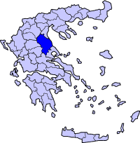
Sarantaporo (Greek: ) is village, part of the synonymous municipality in the Larissa Prefecture, Greece. Population 3588 (2001). Sarantaporo is right next to the Kozani prefecture in West Macedonia bounded a few kilometres to the northwest. The village is near the mountain ranges of Kamvounio to the northwest and the Pieria mountains to the northeast. Sarantaporo is next to the GR-3 (Larissa - Kozani - Niki) and will be linked with a superhighway numbered 3 (A3) with an unscheduled opening date probably with the GR-13 (Elassona - Katerini). Sarantaporo is located west-southwest of Katerini, northwest of Elassona, Tyrnavos and Larissa, east of Grevena and south-southeast of Kozani. The 40th parallel north is about 5 km south of Sarantaporo. Geography The municipality are made up of mountains covering the area with forests as well as grasslands. Farmlands dominate the valley area and around the village especially the western and the central parts. Information Unlike the rest of Thessaly, Sarantaporo did not join Greece until the Balkan Wars where the town was liberated from the Ottoman Turkish yoke which dominated for over 550 years on October 1912 during the Battle of Sarantaporo which saw Greek victory in the First Balkan Wars. Sarantaporo finally became a part of Greece in 1913 which finished the oppresive Turkish rule. The Sarantaporo Gorge was the strategic location for the battle. The village's name during the Ottoman rule was Glikovon (Γκλίκοβον). Sarantaporo became a municipality in 1994 become one of the first Capodistrian municipalities ever created. The area features archaeological findings dating back to the pre-Classical years up to the Ottoman rule. Other Sarantaporo has a schools, the only lyceum (middle school) and gymnasium (high school), banks, churches, a post office, a police station, a pharmacy and a square (plateia). Population Year village population Municipal population 1981 817 - Division of the municipality
Retrieved from "http://en.wikipedia.org/"
 |
|
|||||||||||||||


|
|