|
|
Aigeira, Aigira or Aegira (Greek: Αιγείρα, older: Αίγειρα), also Egira, Eyira, Aiyira is a community located about 500 m SW of the Gulf of Corinth in the northeastern part of the prefecture of Achaea. It is located in GR-8 and has an interchange connecting the new highway with GR-8A and E65. Distance from Patras is 67 km E, about 4 km NE of Akrata and 148 km W of Athens. The municipality is the easternmost in the prefecture.
Nearest places
- Akrata (west)
- Seliana (west)
- Sinevro (northwest)
Division of the municipality
- Aigeira / Δ.δ. Αιγείρας -- η Αιγείρα [ 1673 ]
- Aiges / Δ.δ. Αιγών [ 614 ]
- Aigeira / οι Αιγές [ 116 ]
- Almyros / ο Αλμυρός [ 70 ]
- Lampinos / ο Λαμπινός [ 428 ]
- Ampelokipoi / Δ.δ. Αμπελοκήπων [ 568 ]
- Ampelokipoi / οι Αμπελόκηποι [ 433 ]
- Paliokatona / τα Παλιοκάτωνα [ 70 ]
- Pimpaiika / τα Πιμπαίικα [ 65 ]
- Vala / Δ.δ. Βελάς -- η Βελά [ 119 ]
- Exochi / Δ.δ. Εξοχής -- η Εξοχή [ 92 ]
- Monastirion / Δ.δ. Μοναστηρίου -- το Μοναστήριον [ 286 ]
- Oasis / Δ.δ. Οάσεως -- η Όασις [ 133 ]
- Perithorion / Δ.δ. Περιθωρίου -- το Περιθώριον [ 164 ]
- Seliana / Δ.δ. Σελιάνας -- η Σελιάνα [ 305 ]
- Sinevron / Δ.δ. Σινεβρού -- το Σινεβρόν [ 97 ]
- Chrysanthion / Δ.δ. Χρυσανθίου [ 461 ]
Historical population:
| Statistics |
| Prefecture: |
Achaia |
| Province: |
Province of Aigalia |
| Location: |
38° 8' 45'' N 22° 21' 3'' E |
Area:
|
103.646 km ²
|
Population: (2001)
|
4512 |
| Communes: |
11 |
Elevation:
-lowest:
-centre:
-highest: |
sea level
around 5 m
around around 300 m |
| Postal code: |
250 10 |
| Area/distance code: |
11-30-26960-3 (030-26960-3) |
| Municipal code: |
0701 |
| Car designation: |
AX |
| Name of inhabitants: |
Aegiran |
| Address of administration: |
Aigeira 250 10 |
| Website: |
www.aigeira.gr
(in Greek and English) |
| Year |
Communal population |
Municipal population |
| 1981 |
1320 |
- |
| 1991 |
1696 |
4211 |
| 2001 |
1673 |
4512 |
The community has a school, a gymnasium, a church, a post office and a(plateia). It has a train station with no building connecting the railway line with Patras - Aigio - Aigeira - Derveni - Xylokastro - Kiato - Corinth. The origin of the name comes from the Ancient Greek word aiges for goats.
The place has 8-story buildings and hotels founded around the city and newer ones in the west. Aigeira also has a traffic light.
Mountains are founded to the south. Forests are founded to the west and east. One of the hill foundede south is named Palaiokastro.
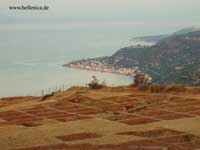
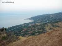
North of Aigeira is a beach which includes spas
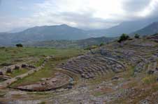
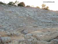
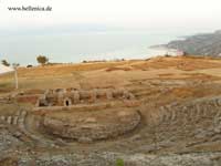
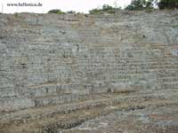
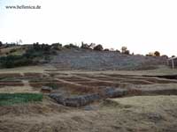
In the archaeological site, the city had a temple during ancient times. It has an antefix decorated with a painted palmette dating back to 500 BC. It also had a harbor.
History
See ancient Aigeira
Other
Its minor soccer team is Thyella Aigira, its uniform is black and white.
Southeast of Aigeira in February 2004 has a protest and were throwing rocks in support of having more money to the farmers. It also has a parking area 1 km E of the interchange.
Mayor
Dimitris Mylonas, since 1998
Links:
|
Ancient Greece
|
Medieval Greece / Byzantine Empire
|
Modern Greece
|
|
Science, Technology , Medicine , Warfare
, Biographies , Life , Cities/Places/Maps , Arts , Literature , Philosophy ,Olympics, Mythology , History , Images
|
Science, Technology, Arts
, Warfare , Literature, Biographies
Icons, History
|
Cities, Islands, Regions, Fauna/Flora ,
Biographies , History , Warfare
Science/Technology, Literature, Music , Arts , Film/Actors , Sport , Fashion
|

|
|