|
|
| Statistics |
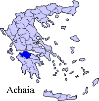
| Prefecture: |
Achaea |
| Province: |
Province of Patras |
Location:
Latitude:
Longitude: |
38°6′19″N, 21°46′55″E |
| Area |
c. 236.75 km2 |
| Population: (2001) |
6.300 |
Elevation:
-lowest:
-centre:
-highest: |
around 50 m
341 m(centre)
around 1,000 m
|
| Postal code: |
250 08 |
| Area/distance code: |
11-30-26940 (030-26940)-2 |
| Municipal code: |
0722 |
| Car designation: |
AX |
| 3-letter abbreviation: |
FAR |
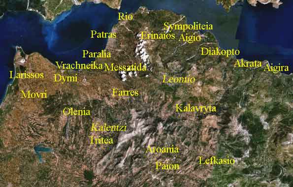
Fares or Farres (Greek: ) is a municipality in the central part of the prefecture of Achaea, Greece. Its seat of administration is in the town Chalandritsa (Greek: Χαλανδρίτσα). It is on a road connecting Patras and Kalavryta. It is located about 17 km SSW of Patras, about 40 km south of the Rio-Antirio bridge/, about 70 km SW of Aigio, 55 km W of Kalavryta, about 140 km NW of Tripoli and about 10 km from GR-9/Patras By-Pass
Nearest places
Kallithea, NW
Division of the municipality
- Chalandritsa / Δ.δ. Χαλανδρίτσης [ 1144 ]
- Chalandritsa / η [ 955 ]
- Kydonies / οι Κυδωνιές [ 32 ]
- Mastoraiika-Stamataiika / τα Μαστοραίικα-Σταμαίικα [ 157 ]
- Vasilikon / Δ.δ. Βασιλικού [ 918 ]
- Vasilikon / το Βασιλικόν [ 521 ]
- Agrilia / η Αγριλιά [ 122 ]
- Kydonies / οι Κυδωνίες [ 82 ]
- Sterna / η Στέρνα [ 55 ]
- Stefani / η Στεφάνη [ 138 ]
- Ellinikon / Δ.δ. Ελληνικού [ 325 ]
- Ellinikon / το [ 49 ]
- Agia Eleousa / η Αγία Ελεούσα [ 198 ]
- Koumaris / ο Κούμαρης [ 23 ]
- Neochorion / το Νεοχώριον [ 21 ]
- Chrysavgi / η Χρυσαυγή [ 34 ]
- Isoma / Δ.δ. Ισώματος -- το Ίσωμα [ 539 ]
- Kalanistra / Δ.δ. Καλανίστρας [ 192 ]
- Kalanistra / η Καλανίστρα [ 133 ]
- Rodia / η Ροδιά [ 59 ]
- Kalanos / Δ.δ. Καλάνου -- ο [ 140 ]
- Kalousi / Δ.δ. Καλουσίου -- το [ 335 ]
- Katarraktis / Δ.δ. Καταρράκτου -- ο [ 221 ]
- Kritharakia / Δ.δ. Κριθαρακίων [ 245 ]
- Kritharakia / τα Κριθαράκια [ 93 ]
- Asterion / το [ 89 ]
- Toskes / οι Τόσκες [ 63 ]
- Lakkomata / Δ.δ. Λακκωμάτων [ 139 ]
- Lakkomata / τα Λακκώματα [ 129 ]
- Tsapournia / η Τσαπουρνιά [ 10 ]
- Miralion / Δ.δ. Μιραλίου -- το Μιράλιον [ 137 ]
- Neon Kobigadion / Δ.δ. Νέου Κομπηγαδίου [ 188 ]
- Neon Kobigadion / το Νέον Κομπηγάδιον [ 144 ]
- Michas / ο Μίχας [ 7 ]
- Platanos / ο Πλάτανος [ 37 ]
- Platanovrysi / Δ.δ. Πλατανόβρυσης [ 456 ]
- Platanovrysi / η [ 155 ]
- Agia Paraskevi / η Αγία Παρασκευή [ 148 ]
- Kato Platanovrysi / η Κάτω Πλατανόβρυση [ 89 ]
- Koimisis / η Κοίμησις [ 64 ]
- Stavrochori / Δ.δ. Σταροχωρίου [ 615 ]
- Ano Stavrochori / το Άνω Σταροχώρι (τ. Σταροχώριον) [ 147 ]
- Dafnoula / η Δαφνούλα [ 341 ]
- Kato Stavrochori / το Κάτω Σταροχώρι (τ. Ζώγας) [ 56 ]
- Chalandritsa / ο Τρούσας [ 71 ]
- Fares / Δ.δ. Φαρών [ 528 ]
- Fares / οι Φαρές [ 476 ]
- Prevedos / ο Πρέβεδος [ 52 ]
- Chrysopigi / Δ.δ. Χρυσοπηγής [ 178 ]
- Chrysopigi / η Χρυσοπηγή [ 122 ]
- Ano Chrysopigi / η Άνω Χρυσοπηγή [ 56 ]
With the construction of the Dam Peiros-Perapeiros is will covered by the waters of the artificial formed lake in the region-
Historical population
| Year |
Communal population |
Municipal population |
| 1981 |
1090 |
- |
| 1991 |
974 |
6483 |
| 2001 |
1144 |
6300 |
The village has a small school, a lyceum, a gymnasium, a health centre, a church, a small post office, a train station and a square (plateia) which includes some trees and a fountain. It also has a museum of folklore and local history located in a restored water mill. It also has a ruined castle which is now a monument.
Until the pavement of the road and the one linking Patras and Kalavryta in the mid-20th century, the village didn't had paved roads or electricity. Until somewhere the 1990s, much of the houses were stone-built.
The area in the mountains had some off-road rally racings.
The Speedway of Patras is situated southwest of the area.
The area near Agios Georgios has a Mycenaean settlement.
The area during the Frankish times was a barony.
Farmlands are to its west. The central part is made up of farmlands which includes mixed farming and pastures in a plain named Farron-Chalandritsa while the eastern and the western part are made up of forests, mountains and valleys.
Toskes is a small village
Ellinikon
Ellinikon (older name Brakoumadi)
Isoma
Isoma (older name Isari)
Katarraktis
Katarraktis is a village (alt. 540 m) (older name Lopesi) with a population 221. The village is c. 25 km from Patras and 5 km from Chalandritsa.
The name Katarraktis means waterfall from the waterfall of the river Peiros which flows through the village.
Around the village there are the remains of a settlement from the Mycenean period in a place called Drakotrypa, other remains of a mesohelladic, mycenaen settlement are in Rodia, a grave from the protogeometric period was found in the place called Aridrakos.
Links
|
Ancient Greece
|
Medieval Greece / Byzantine Empire
|
Modern Greece
|
|
Science, Technology , Medicine , Warfare
, Biographies , Life , Cities/Places/Maps , Arts , Literature , Philosophy ,Olympics, Mythology , History , Images
|
Science, Technology, Arts
, Warfare , Literature, Biographies
Icons, History
|
Cities, Islands, Regions, Fauna/Flora ,
Biographies , History , Warfare
Science/Technology, Literature, Music , Arts , Film/Actors , Sport , Fashion
|

|
|