|
|
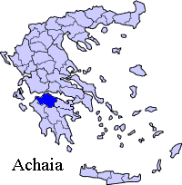
Achaea (uh-kee-uh) or Achaia (uk-eye-uh) (Greek: Αχαα) is a province on the northern coast of the Peloponnese, stretching from the mountain ranges of Erymanthus and Cyllene on the south to a narrow strip of fertile land on the north, bordering the Gulf of Corinth, into which the mountain Panachaicus (1,902 m, the northernmost mountain range in the Peloponnese) projects. Achaea is bounded on the west by the territory of Elis, on the east by that of Sicyon, which, however, was sometimes included in it. The population in 2001 had reached over 300,000. Climate Its climate has hot summers and mild winters. Sunny days dominate during the summer months in areas within the beaches and partially cloudy and rainy in the mountains. Snow is very common during the winter in the mountains of Erymanthus, Panachaicus and Aroania. Winter high temperatures is around the 10°C mark throughout the low lying areas.
History The origin of the name has given rise to much speculation; Achaean is a common term for the Greek troops in Homer. Possibly corresponding are the Ahhiawa of 13th century BC Hittite texts. The Achaeans proper in the Catalogue of Ships are from Argos and Tiryns. However, one theory is that the Achaeans were driven to this region by the Dorian invaders of the Peloponnese. Another Achaea, in the south of Thessaly, called sometimes Achaea Phthiotis, has been suggested to be the cradle of the original tribe. The origin of the name has given rise to much speculation; one theory is that the Achaeans were driven back into this region by the Dorian invaders of the Peloponnese. Another Achaea, in the south of Thessaly, called sometimes Achaea Phthiotis, has been supposed to be the cradle of the race. In the 13th century the Principality of Achaea was founded in Greece after the Fourth Crusade. The Principality of Achaea fell to the Ottoman Empire. In 1821, it became part of Greece. In the 20th century, the Area which excluded Metochi reverted from Ilia as the municipality of Kalotychia became Vouprasias. That part had been a part of Ilia, then Elis during the ancient times. Another reorganization reverted Mataranga and Spata into the prefecture of Achaia and the municipality of Larissos. A mid-1994 late-night (around 3 AM local time) earthquake rumbled the area with a magnitude around 5 on the Richter scale. This was a minor one. It was after another earthquake. A forest fire consumed the northern part of the Panachaicus in the mid-1990s. Population
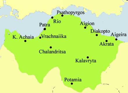
Achaea today has about one-third of its peninsula's inhabitants and two-thirds of Achaia living in the Patra(s) area which is the capital of Achaea and the Peloponnese, and more than half of the population live in the city (municipality). It is also the third largest city in Greece excluding Piraeus. The main industrial area is 20 km south of the city near Phares, and Tsoukoulaiíka and Vrachnaiíka. Aigion is a seaside city with a city hall and a city square is in its heart. The population is 21.061 (2001) Achaea is the most populous area in the Peloponnese peninsula, home to nearly one-third of the inhabitants of the peninsula. Sights and Sports There are two skiing resorts, one on the Panachaicus west of the mountain top (elevation around 1700 m) east of Patras—it will be Nafpaktos's closest because of the new bridge (mid-2004)—and the other on Aroania, sometimes still called Chelmos, near Kalavrita. It is Kalavrita's closest resort. Kalavrita (or Kalavryta) is a town situated more than 70 km (45 miles) to the east via the road from Achaea's capital. A few kilometres to its west is a monastery situated on the peak of the hill. Its name is Aghía Lávra. 12 to 20 km east, is Cave Lakes where lakes are inside this brilliant cave. It is open to tourists, and the length is around 300 to 500 m. A skiing resort is on Mount Chelmos. A narrow gauge railway track runs for 30 km and acts as a tourist attraction (mainly). The track begins near Kalavrita and ends off Diakopton. Patras Economy Achaia has the most supermarkets in the Peloponnese and the western part of Greece. Temeni is a place where the famous spring water Avra (Άυρα) or Aúra is manufactured. It is owned by Tria Epsilon, a division of Coca-Cola Company, some think Buena Vista Company. There are no oil refineries except for a small refinery near Rio. Transport There are two main bus terminals. Veropoulos first opened by the sea, near former GR-9, then Alpha-Beta Vassilopoulos on Akte Dymaion. The main highways are 8 (longest), 8A (E55), GR-9 (E55, E65), GR-31, and GR-33. A beltway which bypasses Patras begun construction in 1990, and extended construction to GR-33 in 1992, Savalia in 1993, East Patra or Patras in 1995, and in 1998 into GR-8. Lights were installed in the early 2000s on the beltway, and opened to traffic on late 2003. It starts from near Roitika and ends just south of Rhion. GR-8 was the first superhighway, along with GR-5 in the prefecture. The beltway is the second, and the bridge will be the third. Its length now has almost 100 km (60 mi) of superhighway. 70 to 75 km until 2003. The Rio-Antirio bridge, which started construction in 2000 (though plans had been made throughout the 1990s, and was supposed to begin in those years), opened in mid-2004, connecting the mainland and the Peloponnese. This eliminated much of the ferry service which has been used for about half a century for automobiles. Since then, there is only the rare ferry service in the city of Aigio(n), which is the ferry route to Aghios Nikolaos in Phocis. Communications and Companies headquartered in Achaea
Statistics and Area Here are the cities ranked by the largest, as of 2003.
Aigeita
¹ suburb of Patras Provinces:
Persons
Sporting teams Football/soccer
Links http://www.geocities.com/world_greek_ geografia/Greece/Axaia/Axaia.htm Retrieved from "http://en.wikipedia.org"
 |
|
||||||||||||||||||||||||||||||||||||||||||||||||||||||||||||||||||||||||||||||||||||||||||||||||||||||||||||||||||||||||||


|
|