|
|
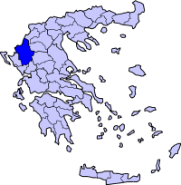
Pramanta (Greek: ) is a municipality in the Ioannina Prefecture, Greece. Population 2194 (2001). The municipality of Pramanta was formed in 1883 and existed until 1912. The new municipality of Pramanta was formed in 1998 Location Pramanta is located south of Metsovo, west of Trikala, north of Arta and east-southeast of Ioannina. Geography Located in the southeastern end of Epirus, the entire area of Pramanta are mountains and pine trees along with forests dominate the whole municipality except for the upper parts especially to the east and the valley areas where farmlands are located. The Arachthos river is 10 km to the west and the Pindos mountains is also 10 km to the east and its mountains are included. Some of its residents live only during the summer months and leave during the winter months. History The area was ruled by the Ottomans, its struggle for Greek freedom failed by the Turks during the Greek War of Independence. Pramanta was liberated at June 1881. After World War II and the Greek Civil War, its buildings were rebuilt, its inhabitants left for larger towns and cities, its population lost by one-fifth between 1981 and 1991, its population recovered between 1991 and 2001 but less than the 1981 census. Pramanta became connected by pavement in the mid to late 20th century. On March 2006, the village and the area was featured on an episode of Travelling in Greece (Menoume Ellada) on ERT. Division of the municipality
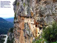
Monastery Theotokou Kipinas, near Christoi Pramanta Pramanta is a mountain village (c. 840 m) 65 km SE of Ioannina. Ampelochori (or Ampelochorion) was known earlier as Skloupo or Kedria Website
 |
|
|||||||||||||