|
|
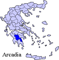
Karatoula or Karatoulas (Greek: Καράτουλας), is a Greek village located around 13 km northeast of Megalopoli, 20 to 21 km north from the nearest interchange with the GR-7/E65 (Kalamata - Megalopoli - Tripoli), about 50 to 55 km southeast of Andritsaina, about 25 km southeast of Karytaina and about 46 km west-southwest of Tripoli. Karatoula had a population of 81 in 2001 for the village. Karatoula is also in the municipality of Megalopoli. Karatoula are connected with a road connecting the Karytaina-Dimitsana Road and the road connecting Megalopoli and Lykocheia. Nearest places * Vangos, east-southeast Geography Karatoula is situated in a mountain slopes. The mountains cover the area and are made up of rocks with grasslands and bushes along with a couple of forests and ungevetated spots at higher elevations. Farmlands are within the village. Its panorama includes the Lykaio mountains to the west, its nearby mountains can be seen. Population Year Population 1981 107 Other Karatoula has a church, and a square (plateia), its nearest school and lyceum (middle school) and gymnasium (secondary school) are in Megalopoli. Links * History and Information about Karatoula
 |
|
|||||||||||||||

|
|