The community has a school, a gymnasium, a church, a post office, a beach, and a square (plateia) Residential houses are lined up with the highway and the shoreline. The area is surrounded by farmland in the north and northeast and forests in the northwest.
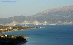
The Port of Antirio where ferry services began in the 1960s carrying vehicles from the Peloponnese to the Mainland Greece. It was not the only harbor carrying vehicles in the area. Ferry services was almost eliminated when the new Rio-Antirio bridge opened. It was reduced to mainly vehicles that are not allowed on the bridge.
The highway is now bypassed and has tolls in the eastern part. The junction with GR-48 (Antirrio - Amfissa) was slightly west of the village.
Adjacent to the port is a lighthouse and the fortress of Antirio.
A mountain which has a few streams is in the north elevating at around 1,100 m. It is closely shaped like a pyramid but at the upper level is like a pyramid but the ridges' width is longer from north to south and the southwestern part is passed by GR-5 at 100 m above sea level. The other is in the north which is around 500 to 600 m and is mainly grassy and forested. A valley is located north of Antirio and some farms are in the southern half of that mountain especially where the boundary with Nafpaktos are located.
Division of the municipality
- Antirrio / Δ.δ. Αντιρρίου [1.108]
- Antirrio / το [1.064]
- Karaoulia / τα Καραούλια [17]
- Myrtia / η Μυρτιά [9]
- Spartorachi / η Σπαρτοράχη [18]
- Makyneia / Δ.δ. Μακυνείας [533]
- Makyneia / η [310]
- Agios Polykarpos / ο Άγιος Πολύκαρπος [26]
- Agrapidokampos / ο [35]
- Riza / η Ρίζα [162]
- Molykreion / Δ.δ. Μολυκρείου [734]
- Molykreion / το [231]
- Ano Platanitis / ο [55]
- Platanitis / ο [368]
- Fragkaiika / τα Φραγκαίικα [80]