|
|
Periphery:West Greece
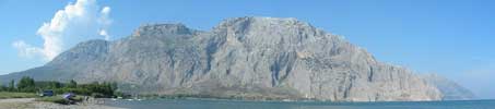
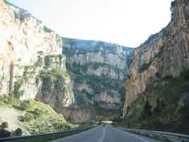
Aetolia-Acarnania, (Greek: Αιτωλοακαρνανία, Aitoloakarnanía, also Aetoloacarnania) is one of the fifty-one prefectures of Greece. It is located in the western part of Greece. The prefecture is a combination of the regions Aetolia and Acarnania. Its capital is Messolongi located in the south. The area is now connected with the Peloponnese peninsula with Rio-Antirio bridge. The surrounding prefectures are Arta in Epirus, a narrow length bordering Karditsa of Thessaly, Evrytania to the northeast and Phocis to the east. It is the largest prefecture in area in Greece. Geography Mountains dominate the north, northeast, west and southeast especially the Acarnanian Mountains. The longest and main river is the Acheloos which ends as a delta in a wetlands in the southwest. The prefecture excludes islands lying in the west which belongs to the Kefallinia prefecture. There is one reservoir and a lake in the central part. Its mountains includes the Panaitoliko in the northeast and the Acarnanian Mountains where a spring water company was founded. Climate Its climate varies from hot summers to mild winters in the low lying areas, cool winters dominate the mountain areas while in the highest elevations, summers are cool and snow and cold weather dominate the winter months in the Panaitoliko.
History For the earlier history about Aitoloacarnania, see Aetolia or Acarnania. Aetolia and Acarnania became a prefecture and merged to form Aitolo-Acarnania. In the 20th century, ferry services with Rio with the Peloponnese began. In the 1950s and the 1960s, ferry services began to use vehicles. A drawbridge linking the island of Lefkada began in the 1960s. The following years, GR-5 bypassed Messolonghi and Agrinio and GR-38 became connected with paved road with Evrytania and Fthiotida. In the late-1980s, the by-pass of Nafpaktos began construction but after paving the road, the signs did not appear and until 1998, left unopened, in 1999, the road was rerepaired and finally opened to traffic. In 2000, the construction of the Rio-Antirio or the Trikoupis Bridge connecting the Peloponnese began construction and was opened to traffic in August 2004. The superhighway, the Ioniki Odos (Ionian Highway/Route) which will run centrally bypassing communities and places at whole is in plan but the date of construction has yet set. On July 29, 2005, a small forest fire burnt forests and grasslands in the area are Xiromeri, no damages were reported. Population history
Transportation
Communications Radio
Television
Newspapers
Provinces
Municipalities
Towns and cities
 |
|
||||||||||||||||||||||||||||||||||||||||||||||||||||||||||||||||||||||||||||||||||||||||||||||||||||||||||||||||||||||||||||||||||||||