|
|
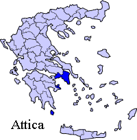
Magoula is a community of the Greek prefecture of Attica, 4 km north of Eleusina, 15 east of Mandra. Magoula is linked with a road linking Elefsina and Agios Thomas in Boeotia, as well as NATO Avenue, the road to Mandra in the west and has interchanges with GR-8/E94 north of Elefsina 2 km south and with the Attiki Odos (number 6) near the hospital. Sykamino also links a road to Chalkoutsi. The area around Sykamino has farmlands located in the Thriasian Plain with urban cores to the south, the mountains including Parnitha to the east lies northward. A small stream flows to the east. Magoula is located about 22 km northwest of Athens, north of Elefsina, ENE of Corinth and southeast of SSE of Thiva. Businesses and agriculture are the most popular industry in Magoula and its surrounding area. The prior to the late-20th century were entirely rural. Housing developments arrived in the 1980s and the 1990s. The population in 2001 was 4005 but has increased significantly now . Magoula is mentioned 1836 as a village of Eleusina. In the year 1875 it had a population of 115.
Agios Dimitrios Church in Magoula, 13-14th century Division of the community
In the central square (plateia) there are two churches : Analipseos tou Sotira and the Agios Dimitrios Church which is from the 13-14th century. It was repaired after it was significantly damaged by the 1999 earthquake.
Magoulas,traditional house Photos by Dionysios Antonopoulos
 |
|
||||||||||||


|
|